-
06 May 2026 09:12:02
- Source: Sharecast
NOT FOR RELEASE, PUBLICATION OR DISTRIBUTION IN WHOLE OR IN PART IN, INTO OR FROM THE UNITED STATES OR ANY JURISDICTION WHERE TO DO SO WOULD CONSTITUTE A VIOLATION OF THE RELEVANT LAWS OR REGULATIONS OF THAT JURISDICTION.
6 May 2026
First Development Resources plc
('First Development", "FDR" or the "Company')
Lander West Gold Target Update
Integrated Geophysical Interpretation and Maiden Drill Programme Planning
First Development Resources plc (AIM: FDR), the UK-based, Australia-focused mineral exploration company with interests in the Northern Territory and Western Australia, is pleased to announce preliminary results from recently completed geophysical surveys at the Lander West gold ("Au") target, part of the Company's 100%-owned Selta Project located in the Northern Territory, Australia.
The geophysical surveys comprised high-resolution airborne magnetics ("AMAG"), radiometrics ("RAD") and ground-based Gradient Array Induced Polarisation ("GAIP"). These datasets have been integrated with geological, geochemical and historical drilling data to refine the Company's understanding of the project area and support the design of a maiden Reverse Circulation ("RC") drilling programme.
The planned drilling is designed to test structurally controlled and intrusion-related Au mineralisation associated with the regionally significant Stafford Gold Trend.
HIGHLIGHTS
· Integrated geological, geophysical and geochemical interpretation has significantly refined the structural and lithological model for Au targeting at Lander West.
· Key geological features identified include granitic contacts beneath thin sand cover, interpreted buried intrusions, major shear zones, faults and fold structures-features known to host significant Au mineralisation both in Australia and globally.
· Phase I RC drilling programme of up to ~3,000 metres, to be executed in two sub-phases comprising an initial c.2,000 metre programme targeting approximately 10 priority drillholes, followed by a flexible c.1,000 metre follow-up phase subject to field observations and results.
Tristan Pottas, Chief Executive Officer of FDR, commented:
"The completion of this integrated geophysical survey programme represents a significant step forward in defining high-quality drill targets for Au at Lander West. By combining new high-resolution magnetic, radiometric and IP datasets with existing geological and geochemical information, we have materially improved our understanding of the structural architecture controlling mineralisation.
Importantly, the recent survey work has identified a compelling combination of shear-related and intrusion-related Au targets, including a large interpreted buried granite body that may have acted as a heat and fluid source driving mineralisation.
The presence of multiple high-priority targets associated with major structures within the Stafford Gold Trend provides strong confidence as we advance to our maiden RC drilling programme. We now look forward to drill testing these targets and unlocking the project's potential."
INTEGRATED INTERPRETATION AND TARGETING
Following completion of the GAIP survey, FDR's Perth-based consultants, Resource Potentials Pty Ltd ("ResPot"), undertook an integrated review of all available datasets, including AMAG, RAD, GAIP, geochemistry and historical drilling.
This work has significantly improved the definition of the geological architecture at Lander West (Figure 1), which is largely concealed beneath shallow sedimentary cover. Interpretation is ongoing to identify additional Au targets.
Key interpreted features include:
· Contacts between prospective granite bodies and surrounding metasedimentary and volcanic host rocks,
· Buried granitic intrusions, plugs and porphyry dyke systems,
· Major shear zones and fault structures,
· Fold axes, dipping limbs and structural corridors, and
· Younger mafic dyke intrusions post-dating the Au mineralising event.
The mineralised corridors are interpreted to lie between two large granite batholiths, likely acting as heat sources driving hydrothermal fluid flow and forming shear-hosted Au systems. Historical shallow drilling suggests a stronger association with the northern batholith, while structural control is evident in the southern target area.
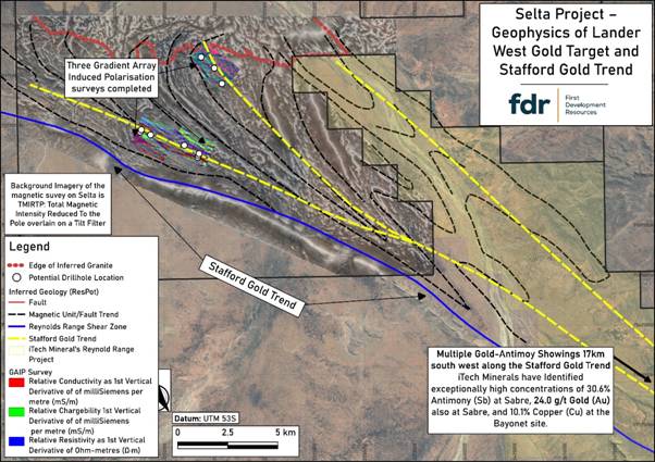
Figure 1:Interpreted large-scale structural controls on the Lander West gold targets. Interpretation of these structures has been further refined following the recent completion of AMAG / RAD and GAIP geophysical surveys by FDR.
INTRUSION-RELATED GOLD SYSTEM TARGETING
Geophysical interpretation has identified a large intrusion-related target zone in the northern licence area. This is interpreted as a buried granitic batholith beneath thin sedimentary cover, previously unmapped and unexplored for Au and other minerals such as copper ("Cu") and lithium ("Li"), despite anomalous geochemistry in historical shallow drilling.
This interpretation is supported by:
· Magnetic and radiometric responses consistent with felsic intrusive rocks, interpreted as late-stage and comparable in age to "fertile" granites in the region,
· A coincident regional gravity low, and
· Supporting topographic signatures from digital elevation and geological datasets.
These features are consistent with a late granite intrusion potentially associated with Au, antimony ("Sb"), Li and rare-earth elements ("REE").
Additional smaller felsic porphyry stocks and dykes have also been identified. Where felsic intrusive rocks are intersected during drilling, selective sampling may be undertaken to support potential age-dating and further geological analysis.
ROLE OF THE GAIP SURVEY
The GAIP survey has provided key subsurface information on conductivity and chargeability, aiding identification of structures and potential sulphide mineralisation associated with Au deposition.
It has been particularly effective in confirming:
· Shear zones,
· Lithological boundaries, and
· Structural corridors
These are critical target zones for both shear-hosted and intrusion-related Au systems.
Drilling results will be used to calibrate GAIP responses against mineralisation, improving its effectiveness as a targeting tool.
PHASE I RC DRILL PROGRAMME DESIGN
A maiden Phase I RC drilling programme has been designed as a staged programme of up to ~3,000 metres, comprising an initial priority sub-phase followed by a flexible follow-up phase.
The programme is expected to commence with an initial sub-phase targeting approximately 10 high-priority drillholes (c.2,000 metres). These holes have been selected based on integrated geological, geophysical and geochemical datasets and are designed to test the most prospective structural and intrusion-related Au targets.
A second, follow-up sub-phase of up to c.1,000 metres has been provisionally planned, comprising additional drillholes that will be refined and prioritised based on observations and results from the initial drilling. These follow-up holes are therefore considered flexible and subject to change as new data is acquired during the programme.
In total, the current drill plan comprises up to 16 holes for approximately 3,000 metres; however, the final number, positioning and depth of drillholes will remain adaptable as the programme progresses.
Targets include:
· Major structural zones (shears, faults, fold "jogs") coincident with geochemical anomalies,
· Edges of magnetic anomalies interpreted as intrusive bodies in contact with host rocks (including skarn and intrusion-related targets), and the structural controls related to them,
· Coincident GAIP chargeability and magnetic anomaly zones interpreted to be caused by hydrothermal alteration associated with both shear and intrusion-related Au targets, and
· Anomalous Au and arsenic ("As") results from previous shallow drilling.
Drill collar locations have been optimised using integrated datasets (Figure 2), with flexibility retained to refine targets as results from the initial sub-phase are received.
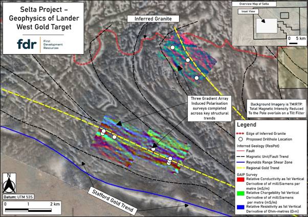
Figure 2: Lander West Phase I RC drill hole locations (white dots), which have been optimised following integration of AMAG / RAD and GAIP geophysical survey results.
CONTEXT WITHIN THE STAFFORD GOLD TREND
Lander West lies within the Stafford Gold Trend, a regionally significant structural corridor known for hosting Au and Sb mineralisation, as well as recently discovered high-grade Li pegmatites.
Exploration 15-20 km to the southeast has reported results of up to 30.6% Sb and 24 g/t Au.
The Company is targeting:
· Shear-hosted Au mineralisation within the Stafford Gold Trend, and
· Intrusion-related Au systems associated with felsic intrusions to the north.
The combination of a large interpreted late granite intrusive system and well-developed structural controls significantly enhance prospectivity and supports the Company's maiden drill campaign.
NEXT STEPS
· Final planning and drilling contractor engagement,
· Earthworks clearing of approved access routes and drill pads,
· Mobilisation and commencement of the Phase I RC drilling programme, targeted for mid-year, with all necessary approvals now secured, including the Environmental (Mining) Licence and the Northern Territory Government's Notice of Authority to Commence, and
· Ongoing geological and geophysical interpretation and refinement of targets during drilling.
The Company looks forward to commencing its maiden RC drilling programme at Lander West and will update shareholders as preparations are finalised and the drilling commences.
Qualified Person Statement
The technical information contained in this disclosure has been reviewed and approved by Mr Nicholas O'Reilly (MSc, DIC, MIMMM QMR, MAusIMM, FGS), who is a qualified geologist and acts as the Qualified Person under the AIM Rules - Note for Mining and Oil & Gas Companies. Mr O'Reilly is a principal consultant working for Mining Analyst Consulting Ltd which has been retained by First Development Resources plc to provide technical support.
GLOSSARY
|
Term |
Definition |
|
AMAG (Airborne Magnetics) |
A geophysical survey method that measures variations in the Earth's magnetic field from the air to map subsurface geological structures. |
|
Arsenic (As) |
A chemical element commonly associated with Au mineralisation and used as a pathfinder in geochemical exploration. |
|
Batholith |
A large, deep-seated body of intrusive igneous rock, typically granitic in composition. |
|
Chargeability |
A measure of a material's ability to temporarily hold an electrical charge, often used to detect sulphide mineralisation in IP surveys. |
|
Conductivity |
The ability of a material to conduct electrical current, used in geophysics to identify different rock types and alteration zones. |
|
Copper (Cu) |
A base metal often associated with hydrothermal systems and sometimes co-located with Au mineralisation. |
|
Dyke |
A sheet-like body of igneous rock that cuts across existing rock layers. |
|
Felsic |
A term describing silica-rich igneous rocks, typically light-coloured and commonly associated with granitic compositions. |
|
Fold |
A bend or curvature in rock layers caused by tectonic forces. |
|
GAIP (Gradient Array Induced Polarisation) |
A ground-based geophysical method that measures chargeability and resistivity to identify subsurface structures and sulphide mineralisation. |
|
Geochemistry |
The study of the chemical composition of rocks, soils and sediments to identify anomalous element concentrations. |
|
Geophysics |
The application of physical measurement techniques to investigate subsurface geological features. |
|
Granite |
A coarse-grained felsic intrusive igneous rock commonly associated with mineralising systems. |
|
Hydrothermal |
Relating to hot fluids circulating within the Earth's crust that can transport and deposit minerals. |
|
Intrusion (Intrusive Body) |
A body of igneous rock formed when magma solidifies beneath the Earth's surface. |
|
Intrusion-Related Gold System |
A type of mineral system where Au mineralisation is genetically linked to felsic intrusive rocks. |
|
Lithology |
The physical characteristics and composition of a rock unit. |
|
Lithological Boundary |
The contact between two different rock types. |
|
Lithium (Li) |
A light metal commonly found in pegmatites and increasingly important for battery technologies. |
|
Magnetic Anomaly |
A local variation in the Earth's magnetic field caused by differences in the magnetic properties of subsurface rocks. |
|
Mafic |
Describes igneous rocks rich in magnesium and iron, typically darker in colour. |
|
Metasediments |
Sedimentary rocks that have been altered by heat and pressure without melting. |
|
Mineralisation |
The process by which economically valuable minerals are introduced into a rock. |
|
Pegmatite |
A very coarse-grained igneous rock often enriched in rare elements such as Li and REE. |
|
Porphyry |
An igneous rock with large crystals set in a finer-grained groundmass, often associated with mineral deposits. |
|
Radiometrics (RAD) |
A geophysical method that measures natural gamma radiation to identify variations in surface and near-surface geology. |
|
Rare Earth Elements (REE) |
A group of chemically similar elements used in high-technology applications and often found in specialised mineral deposits. |
|
RC (Reverse Circulation) Drilling |
A drilling technique that uses compressed air to return rock chips to the surface for sampling. |
|
Resistivity |
A measure of how strongly a material resists electrical current, used to differentiate rock types and structures. |
|
Shear Zone |
A zone of intense deformation where rocks have been displaced along a planar structure. |
|
Shear-Hosted Gold System |
A type of Au deposit controlled by deformation zones such as faults and shear zones. |
|
Skarn |
A calc-silicate rock formed by metasomatic alteration, often associated with mineralisation near intrusions. |
|
Structural Corridor |
A zone of aligned geological structures that can control the movement of mineralising fluids. |
|
Structure (Geological) |
Any feature in rocks formed by deformation, such as faults, folds or shear zones. |
|
Sulphide Mineralisation |
The occurrence of sulphide minerals, often associated with metal deposits including Au. |
|
Target (Exploration Target) |
A geological area identified as having potential to host mineralisation based on available data. |
|
Uranium (U) |
A radioactive element used as a fuel source and often explored for in sedimentary and igneous environments. |
For further information visit www.firstdevelopmentresources.com or contact the following:
|
First Development Resources plc Tristan Pottas (CEO) |
Tel: +44 (0) 20 3778 1397 |
|
Beaumont Cornish Limited Nominated Adviser Roland Cornish / Asia Szusciak |
Tel: +44 (0) 20 7628 3396 |
|
SI Capital Limited Broker Nick Emerson
|
Tel: +44 (0) 1483 413 500 |
Beaumont Cornish Limited ("Beaumont Cornish") is the Company's Nominated Adviser and is authorised and regulated by the FCA. Beaumont Cornish's responsibilities as the Company's Nominated Adviser, including a responsibility to advise and guide the Company on its responsibilities under the AIM Rules for Companies and AIM Rules for Nominated Advisers, are owed solely to the London Stock Exchange. Beaumont Cornish is not acting for and will not be responsible to any other persons for providing protections afforded to customers of Beaumont Cornish nor for advising them in relation to the proposed arrangements described in this announcement or any matter referred to in it.
ABOUT FIRST DEVELOPMENT RESOURCES
First Development Resources' assets comprise eight granted tenements covering a total area of 2,314.4km2. Five of the tenements, comprising three prospective copper-gold projects, are located in Western Australia (WA) while the remaining three tenements, comprising a rare-earth element (REE), uranium, lithium and gold project, are located in the Australian's Northern Territory. All tenements are wholly owned by FDR. The assets are a mixture of drill ready and earlier stage exploration.
The WA Projects include the Company's Wallal Project as well as Ripon Hills and Braeside West Projects situated in the Paterson Province, which is widely regarded as one of the most productive regions in Australia for the discovery of world-class gold-copper deposits, and which is home to several world-class mines and more recent discoveries.
The Selta Project in the Northern Territory is located in an area considered highly prospective for uranium and rare-earth element mineralisation along with base and precious metal mineralisation. Numerous companies are actively exploring within the region.
Beyond the existing portfolio, FDR is actively looking to expand its portfolio through the acquisition of early-stage exploration projects in Australia.
SELTA PROJECT INDICATIVE OPERATIONAL TIMELINE
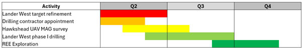
Indicative operational milestones for exploration activities at the Selta Project. Schedule subject to change.
RNS may use your IP address to confirm compliance with the terms and conditions, to analyse how you engage with the information contained in this communication, and to share such analysis on an anonymised basis with others as part of our commercial services. For further information about how RNS and the London Stock Exchange use the personal data you provide us, please see our Privacy Policy.